
Recent Navigation Warnings of China Waters No.109
We have obtained the recent navigation warnings of the China Waters issued by China MSA. Please see the following the free translations by the law firm in Shanghai, China, Sloma & Co.
///QUOTE///
- Fault Repair on S1.1 of the NCP (New Crossing-Pacific Cable System) in East China Sea
(MSA Translation)
HHT (2021) No. 502
China MSA 13 October 2021
- Work duration: 14 October 2021 – 9 December 2021, day-night operation.
- Work site: water areas of East China Sea outside north branch of Changjiang Estuary, bounded by the following six points:
A) 31°45′31.8″N/122°10′45.6″E;
B) 31°46′03.0″N/122°10′34.8″E;
C) 31°47′58.2″N/122°16′40.8″E;
D) 31°48′05.0″N/122°22′01.0″E;
E) 31°47′21.0″N/122°22′01.4″E;
F) 31°47′28.2″N/122°16′49.8″E.
- Work mode: Workboat “CS FU HAI” (LOA: 105.8m, molded breadth: 20m) will detect the fault location, salvage and cut off the defective cable, splice, lay and repair the cable, bury and repair the cable in order along route of S1.1 of NCP in the work site. During the operation, the navigation speed of the workboat is relatively slow.
- Cautions:
- The workboat should exhibit lights and shapes as regulated and keep AIS on normally.
- The workboat should strengthen duties on VHF16 and the report of movement of the vessels, contact with the passing vessels voluntarily and implement security works.
- Vessels passing the work site should sail cautiously and pay attention to the avoidance.
- Irrelevant vessels are forbidden to enter the circular water area centered by the workboat, with a radius of 500m.
- The operation should be suspended in case the wind force is greater than 7 (Beaufort scale) or the visibility is less than 1 nautical mile.
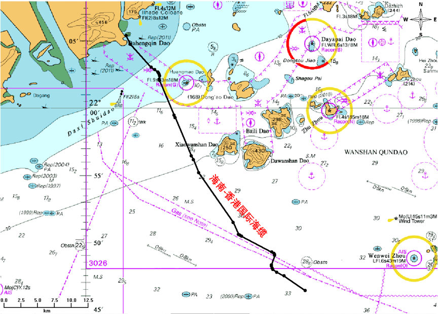
- Announcement on Route of H2HE (Hainan to Hong Kong Express) (Section under the Jurisdiction of Zhuhai MSA)
(MSA Translation)
ZHT (2021) No. 127
China MSA 15 October 2021
The laying operation of H2HE (section under the jurisdiction of Zhuhai MSA) has been completed. The route of the submarine cable is hereby announced as follows:
- See Attachment 1 of the coordinate table of the route of H2HE (section under the jurisdiction of Zhuhai MSA).
- See Attachment 2 of the sketch map of the route of H2HE (section under the jurisdiction of Zhuhai MSA).
- In order to protect the safety of the submarine cable, in accordance with Regulations on Protection of Submarine Cable and Pipeline, vessels are forbidden to carry out operations which might damage the safety of submarine cable, such as sand excavating, drilling, piling, dragging anchor and trawl fishing.
Attachment 1: Coordinate Table of the Route of H2HE (Section under the Jurisdiction of Zhuhai MSA)
Coordinate system: CGCS2000
| No. | Latitude | longitude |
|---|---|---|
| 1 | 22°05'23.760″N | 113°33'16.980″E |
| 2 | 22°04'44.742″N | 113°33'37.794″E |
| 3 | 22°03'02.832″N | 113°35'16.872″E |
| 4 | 22°02'51.420″N | 113°35'33.762″E |
| 5 | 22°02'40.806″N | 113°35'49.302″E |
| 6 | 22°02'36.384″N | 113°35'53.148″E |
| 7 | 22°02'29.712″N | 113°35'56.388″E |
| 8 | 22°02'23.466″N | 113°35'57.558″E |
| 9 | 22°02'10.002″N | 113°35'56.268″E |
| 10 | 22°02'03.744″N | 113°35'57.258″E |
| 11 | 21°59'27.252″N | 113°37'06.852″E |
| 12 | 21°59'16.956″N | 113°37'11.910″E |
| 13 | 21°56'25.200″N | 113°38'29.094″E |
| 14 | 21°56'09.096″N | 113°38'39.696″E |
| 15 | 21°55'09.846″N | 113°39'05.016″E |
| 16 | 21°51'27.114″N | 113°41'49.866″E |
| 17 | 21°50'33.726″N | 113°42'15.258″E |
| 18 | 21°50'29.574″N | 113°42'20.748″E |
| 19 | 21°50'25.056″N | 113°42'30.096″E |
| 20 | 21°49'14.352″N | 113°44'54.420″E |
| 21 | 21°49'09.144″N | 113°45'04.494″E |
| 22 | 21°49'03.672″N | 113°45'07.992″E |
| 23 | 21°48'58.776″N | 113°45'08.526″E |
| 24 | 21°48'15.942″N | 113°44'52.506″E |
| 25 | 21°48'11.340″N | 113°44'52.566″E |
| 26 | 21°48'02.688″N | 113°44'56.268″E |
| 27 | 21°47'56.982″N | 113°44'59.550″E |
| 28 | 21°47'43.704″N | 113°45'18.036″E |
| 29 | 21°47'27.810″N | 113°45'53.682″E |
| 30 | 21°46'21.672″N | 113°47'34.836″E |
Attachment 2: Sketch Map of the Route of H2HE (Section under the Jurisdiction of Zhuhai MSA)
- Announcement on Anchoring of the Offshore Platform in Qiongzhopu Strait
(MSA Translation)
QHKHT (2021) No. 39
China MSA 19 October 2021
Relevant units and vessels,
The offshore platforms of China Electronic Science and Technology Marine Institute of Information Technology Co., Ltd. will anchor in waters of Qiongzhou Strait, relevant issues are announced as follows:
- Location of anchoring
(I) Platform I: Around 2nm to the north of southwest shoal of east side of Qiongzhou Strait (20°12′53.2″N / 110°36′24.2″E). (II) Platform II: Around 4nm to the northwest of Xinhaigang of Qiongzhou Strait (20°05′57.3″N / 110°05′28.8″E) - Time of anchoring
19 October 2021 - 30 September 2022 - Characteristics of Platform
The height of platform is 32.5m, draught is 16.5m and maximum diameter is 18m. It is a triple-upright pole platform with small waterplane area, the poles are painted with warning sign of “High Voltage”. There is exhibited light set in obvious places with yellow flash of 12 seconds (0.5+1.5). The height of the light is 12m with a range of 5nm. - Laying mode:
Unattended operation adopting single-point anchoring (300-ton gravity anchor) and the length of anchor chain is 250m. - Cautions
- The construction unit should implement all the safety and anti-pollution measures for the platform during the anchoring, display signals as regulated and implement relevant safeguard measures and plan.
- The management unit of the platforms should conduct routine maintenance on the platforms to make sure that they comply with relevant technical specification.
- Passing vessels should strengthen lookout, keep a safe distance with the platforms and sail cautiously for the safety matter.
- Operation of Geological Exploration in Waters of West of Maji Mountain
(Sloma Translation)
ZHT (2021) No.131
China MSA 20 October 2021
- Work duration: 21 October 2021 – 31 December 2021.
- Work site: water areas nearby west side of Maji Mountain, bounded by the following 6 points (2000 National Geodetic Coordinate System):
A) 30°41′12″N、122°25′05″E;
B) 30°41′41″N、122°24′53″E;
C) 30°41′26″N、122°24′06″E;
D) 30°41′11″N、122°23′43″E;
E) 30°40′39″N、122°23′57″E;
F) 30°40′31″N、122°24′25″E.
- Work boat and mode: “Rui Chang 2”, “Hui Tong 828” and “Zhe Ding Gong 1021” will conduct geological exploration operation in the above water area. Work boats will drop horoscopes anchors at the bow and stern of the boat, each anchor chain is 80 meters in length.
- Cautions:
- Workboats should display lights and shapes as regulated and keep watch on VHF 16 during the operation.
- Irrelevant vessels are forbidden to enter the work site.
- “Zhe Pu Gong 9” and “Zhe Ding Gong 11” (contact via VHF16) will perform security duties on site, any vessels sailing near the work area should obey the command of the on-site guard ships.
DISCLAIMER
Please be advised that all the above navigation warnings were the important pieces selected from the official website of MSA China or that of other local MSAs. Sloma shall not be liable for the veracity of the above navigation warnings or the accuracy of their English and Japanese translations. Neither shall Sloma be liable for any person’s/party’s possible losses/damage which may result from relying upon the above navigation warnings.
Junmao Jiang
Sloma & Co.
26 October 2021
///UNQUOTE///
For further information, please click here.
Most read News
- 【オンラインセミナー】他船との衝突損害
- Club’s Rule Book and Correspondents List for Policy Year 2022
- Guinea-Caution to Robberies at Conakry